


The Diapontia islands are located in the Ionian Sea, at the westernmost point of Greece, just 10 km away from cosmopolitan Corfu; diapontia islands can be seen as a gateway to the Adriatic Sea and the rest of Europe. The Diapontia Archipelago includes 153 islands, islets and rocks whose name denotestheir geographical location: “Diapontia”, which means “to beamong the Ionian and Adriatic Seas”. This island complex is a ‘mosaic’ of little islands and islets, rightlydescribed asparadisal and are hidden gems of the Ionian with their jagged coasts, emerald waters, impressive geological formations, lush vegetation and small communitiesdotted with stone houses and unique views of the endless sea.
The Diapontia Islands consist of three bigger islands: Othoni, Ereikousa and Mathraki as well as nine uninhabited islets:
- Diakopo
- Diaplo
- Karavi
- Kastrino
- Lipso (or Varka)
- Ostrako
- Plaka (or Angira)
- Platia
- Trachia
Diapontia islands were inhabited after the battle of Nafpaktos in 1571, when islanders who were under Venetian rulefled seeking refuge. People from Paxos and Parga arrived at Othoni and as the population grew, they migrated to Mathraki and Erikousa. This explains why the inhabitants of these three islands as well as Paxos island share the same surnames.
Discover Diapontia islands one by one
Othonoi
Othoni is the biggest island of the Diapontia islands complex with 560 inhabitants and is the westernmost point of Greece. It is 40 nautical miles away from Italy and when the atmosphere is clear the Italian Cape of Otranto, Santa Maria di Leuca, is visible.
Sources concerning the original name of the island vary. According to Hesychius (3rd cent. B.C.), the island originally appeared in scripts with the name “Orthonos” when Elephenor, king of Avantes from Euboea, fled to the island after the fall of Troy to atone for the killing of his grandfather, Abas.
Pliny (1st cent. A.D.) refers to the island with the name “Thoronos” and Procopius (6th cent. A.D) mentions the pillage of Corfu by the Ostrogoths in 551 A.D. citing the island “Othoni”.
Other reports concerning the name of the island come from folk researches which are not historically documented and are, therefore, just claims based on oral tradition. Such an example is a report by Charilaos Kollas who, based on local tradition, mentions that the name “Othoni” comes from the word “screen” (Greek:othòni) referencing the white sails of the boats.
According to a legend, Othoni was the island Ogygia, the island of nymph Calypso who seduced Odysseus and kept him prisoner for seven years before he escaped to Corfu on a raft.
The island is renowned for it maritime history which has been documented since the beginning of the 19th century and especially after the unification of the Ionian Islands with Greece in 1864 which allowed the island to take part in free trade.
Until WWII, the Othonian ships traded in the Ionian, Aegean and Adriatic Sea and in the Eastern and Western Mediterranean and the Black Sea.A great part of the population owned its own sailing ships, barges and caiques until the mid 20th century, when they were confiscated during the two World Wars. Maintenance and repairs of these ships took place at the two shipyards of Corfu, atMantouki and Sidari, as well as shipyards abroad, at the Dalmatian and Italian coasts.
Main trade products were the local and Corfiot olive oil that arrived at the coasts of Epirus, Albania, Austria, Italy and Malta. From there, the ships transferred agricultural products and industrial goods or served as means of transport. They also carried garlic, onions, caper and cods, spices and sails from Corfu.
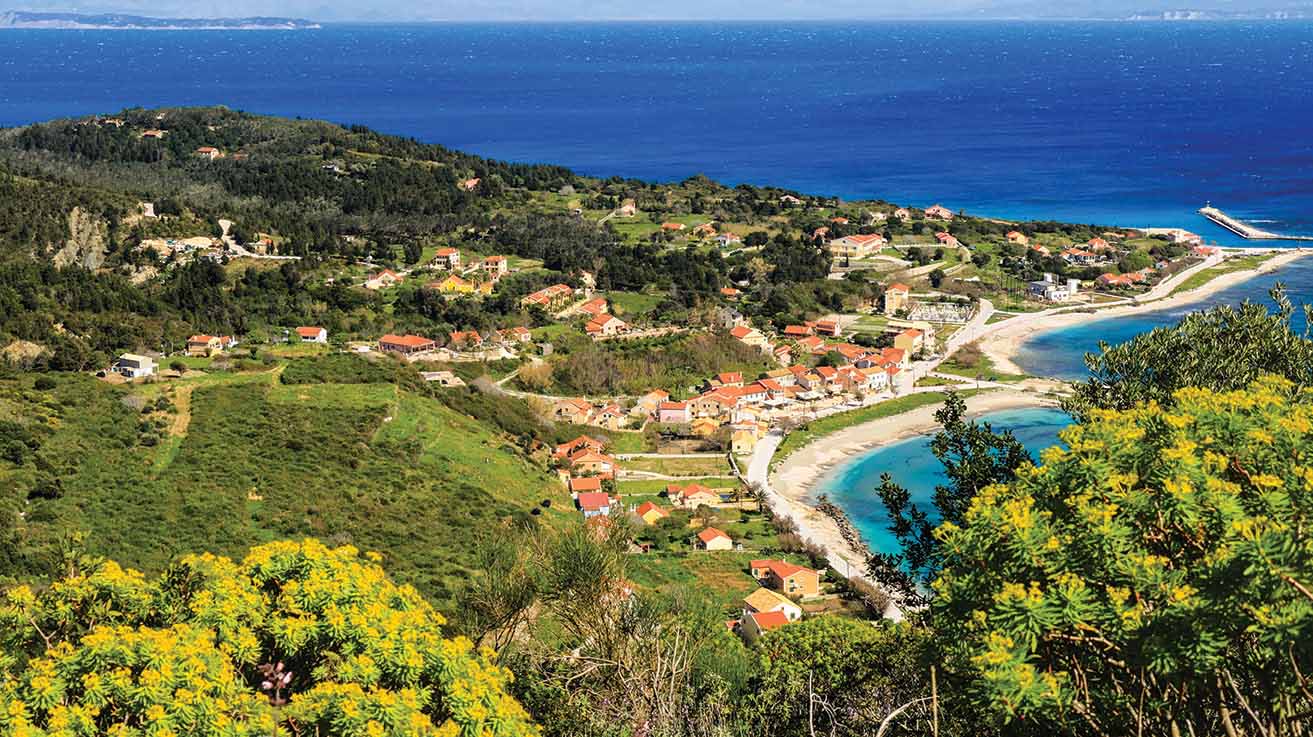
The island has two main settlements: a coastal one called Ammos which is also the main port, and amountainous one which is called Chorio. Two smaller settlements are Kasimatika and Deletatika.
A fishing haven called “Avlaki” is also located in Ammos. The settlement Stavros is located at the hillside of the hill Kalodiki. At the eastern part of the island there is Cape Kastri which features the ruins of a Venetian fortress as well as the impressive lighthouse “Faros” which is built 100 m above the sea level. The lighthouse was built in 1872, destroyed by the Germans during their retreat and was later repaired and reconstructed.
Most of the coasts of the island are steep and rocky. The west coast features the beautiful beach “Aspri Ammos” with Calypso’s Cave. “Aspri Ammos” (White Sand) is a sandy beach with fine white sand, pebbles and crystal clear emerald water. The steep and smooth cut of a vertical rock facadeabove the beach is truly breathtaking.
Calypso’s Cave with its emerald waters is located just a bit further away from the beach. According to the legend, Odysseys was captivated by Calypso’s beauty and remained a prisoner there for seven years. At the northern part of the island, cove Fiki is ideal for diving where the shipwreck of the boat “Sara” lies underneath the surface.
Nowadays, the ferry leaves visitors at “Ammos”, a small cove with a beautiful beach and few local shops. The visitors can approach the mainland through paths and trails, a true hiker dreamland. There is also a hotel and rooms to rent.
It is a unique tourist destination, ideal for sailing and peaceful holidays, as all the diapontia islands.


Ereikousa island is the northernmost Ionian island and the second biggest island of the Diapontia complex with 400 inhabitants, just 6 nautical miles north from Cape Drastis of northern Corfu. It was originally mentioned in scripts by Pliny during the 1stcentury A.D. as Erikoùsa or Ericusa and later in the 2nd century A.D. by Ptolemy. According to local tradition, the island was once deserted and it was inhabited by families of Paxos which migrated from Othoni and settled there. The lush fields make you think that a part of Epirus or Corfu broke off, floated on the sea and eventually got stuck there, at the very edge of Greece, diapontia islands.
Santardo is the highest point of the island, about 130 m high, which boasts an amazing view of the round and green island. To the west of the island, there is the beautiful golden sandy beach of Braghini.
One of the most beautiful parts of the island is Pera Katergo, wherea stone cross tells the story of a nautical disaster that happened there 100 years ago. Pera Katergo is the only area of the island covered by rocks. In the past, this hill was a local quarry,where workers used dynamite to detach stone in order tosculpt it.
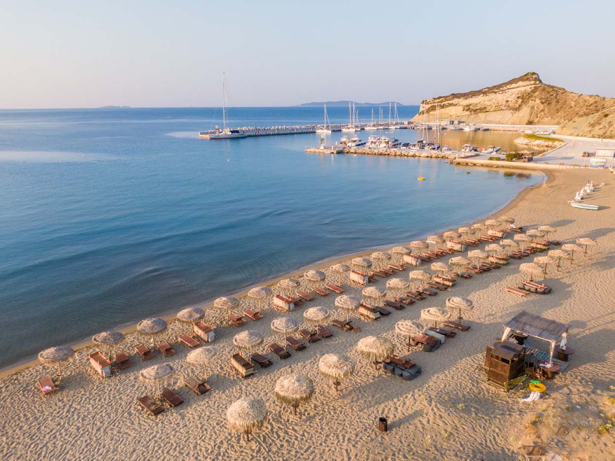
Porto is connected with Corfu port and during summer it is also connected with Sidari. The island has an excellent heliport as well as a rural medical practice, a hotel and room rentals.


Mathraki is the smallest of the Diapontia islands. It is located at the west of Corfu and just 4.5 nautical miles from Kavokefali of St. Stephanos. It looks as if it has emerged from the sea along with its ‘friends’, two huge rocks. Legend has it that these rocks, Karavi and Arkous used to be a Turkish ship and a boat full of bandits who sailed to rob the church of Saint Nicholas. The saint punished them by turning them into rocks and since then the ship and the boat are beaten by the waves.
Portelo beach takes over most of the northeastern part of the island; its water is crystal clear and deepens gradually whereas the northwestern coast is a real heaven for divers and spear gun fishing. The southern coast hosts the picturesque fishing port Apidia which boasts views of amazing sunsets.
Lush and full of smaller communities which are interconnected with picturesque trails, Mathraki offers visitors a magical experience. You can also visit cove Fiki with its sandy beach opposite the islet Trachia, as well as Kontrakas, an old port with a picturesque settlement.
The main port of the island is Plakes which is connected to Corfu from the port of Saint Stephanos and Sidari. The two main villages of the island, Ano Mathraki and Kato Mathraki are built at the two edges of the island. Visitors can find two hotels with beautiful views and traditional tavernas.
Explore Diapontia islands one by one this summer!


Source
ΙΟΝΙΟ ΠΑΝΕΠΙΣΤΗΜΙΟ. Τμήμα Ιστορίας, ΚΑΡΔΑΚΑΡΗ, Δήμητρα-Χρυσούλα. (2001). “Το Αρχιπέλαγος των Διαποντίων. Οθωνοί, ένα Ακριτικό Νησί”, https://marehist.gr/gr/tributes/07.02.01
ΙΟΝΙΟ ΠΑΝΕΠΙΣΤΗΜΙΟ. Τμήμα Ιστορίας, ΚΑΡΔΑΚΑΡΗ, Δήμητρα-Χρυσούλα. (2003). “Οθωνοί, το Νησί των Ναυτικών”, https://marehist.gr/gr/tributes/07.02.03
Μηχανή του Χρόνου (2015). “Οι ‘χαμένοι’ παράδεισοι του Ιονίου όπου η Καλυψώ παγίδευσε τον Οδυσσέα”, http://news247.gr/eidiseis/mixani-tou-xronou/mhxanh-toy-xronoy-oi-xamenoi-paradeisoi-toy-ionioy-opoy-h-kalypsw-pagideyse-ton-odyssea-kai-h-ereikousa-toy-tsipra.3599573.html 2015
Ortsa.gr: το πρώτο ηλεκτρονικό περιοδικό για τη θάλασσα. (2017). “Διαπόντια Νησιά”, http://www.ortsa.gr/%CE%B4%CE%B9%CE%B1%CF%80%CF%8C%CE%BD%CF%84%CE%B9%CE%B1-%CE%BD%CE%B7%CF%83%CE%B9%CE%AC/
IEFIMERIDA (2015). “Τα άγνωστα Διαπόντια Νησιά: το δυτικότερο σημείο της χώρας – κρυστάλλινα νερά, ατελείωτες αμμουδιές, τοπίο μαγεία”, (2015), http://www.iefimerida.gr/news/209356/ta-agnosta-diapontia-nisia-dytikotero-simeio-tis-horas-krystallina-nera-ateleiotes
Advertisement

Discussion